Role as Emergency Responder after September 11th Attacks
Role as Emergency Responder after September 11th Attacks
Digital Basemap Coordinates Emergency Responders
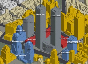
NYCMAP was delivered six months before the September 11, 2001 World Trade Center Terrorist Attacks. NYCMAP enabled dozens of federal, state and local agencies, and corporate and nonprofit groups to respond more effectively to the 9/11 event. Urban Logic’s federal and corporate network of allies supplied data and resources to the Emergency Mapping and Data Center at the Mayor’s Command Center. GIS at Ground Zero – Spatial Technology Bolsters Response and Recovery (GeoWorld – January 2002)
Liaison to Federal-State-Industry-Local GeoSpatial Resources
Through its advisory role with the Federal Geographic Data Committee (FGDC) leadership, by the afternoon of September 11, Urban Logic arranged to obtain the first aerial photographs of Ground Zero, which Bruce Cahan and Hunter Professor Ahern printed out at CARSI Lab, and then carried through Midtown traffic into the temporary Command Center, at the Police Academy, located at 20th Street and Third Avenue, diagonally across northeasterly from 32 Gramercy Park building, the site of the 1989 steam pipe explosion.
In the months after September 11th, Urban Logic provided liaison and logistical support for the Fire Department of New York (FDNY), the New York Police Department and dozens of other agencies, including arranging for CBS News to disseminate updated damage assessment and other maps to the global media, tracking the contracts, payments and work load of the EMDC, obtaining critical infrastructure data from Con Ed, title companies and other sources, and arranging for nautical maps in response to the crash of American Airlines Flight 587.
Sharing Lessons Learned
Urban Logic briefed Congressional staffers and other professionals on the geospatial response to the 9/11 World Trade Center Attacks. With SUNY’s Center for Technology in Government, Urban Logic led NSF-funded research to collect and understand the oral history and lessons learned in the first-person accounts of the geospatial and other emergency responders. With the Council for Excellence in Government, Urban Logic co-produced a video shot at the Command Center and distributed to all members of Congress that featured geospatial responders like Alan Leidner, director of the Emergency Mapping and Data Center, and architect of NYCMAP. Urban Logic arranged for cutting-edge technologies to be deployed in New York City after 9/11, including SensorWeb interoperability then being piloted by EPA and OpenGIS Consortium so as to better detect biological, natural hazards or other threats.
Papers and Presentations
Sustainable Resiliency: Financing Environmental, Homeland Security, and Other Infrastructure Systems, ESRI User Conference Homeland Security Track (San Diego July 27, 2005).
Learning from Crisis: Lessons in Human and Information Infrastructure from the World Trade Center Response, (Social Science Computer Review, 22, 1, 5-10 (February 2004), (co-author on NSF-funded research).
Turning to Digital Government in a Crisis: Coordinating Government, Business & Nonprofit Services in Response to the World Trade Center Attacks of September 11, 2001, (co-author on NSF-funded research), presented at the National Digital Government Research Conference, dg.o2003, Boston.
United States’ Experience with Public-Private Partnerships: Elements of Effective Public-Purpose Partnerships, OECD Conference on Public-Private Partnerships (Paris – June 20, 2002), OECDPublicPrivatePshipPaper053102Final
GIS at Ground Zero – Spatial Technology Bolsters Response and Recovery (GeoWorld – January 2002)..


